Transit-Efficient Housing
When exploring housing options, consider your commute. Selecting housing in a neighborhood with great transit service can make your commute faster, more reliable, more productive and lower impact while helping you save money. These routes offer some of the fastest and most reliable one-seat rides to the La Jolla campus. Looking for housing within a brief 5-6 block walk or one-mile bike ride from these transit centers could make your commute significantly more efficient.
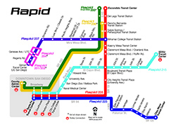
Consider neighborhoods along the Rapid 237 express bus line. (map)
- Miramar College Transit Station: ~41 minutes (neighborhood profile, map)
- Black Mountain Rd. (neighborhood profile, map)
- Camino Ruiz: ~32 minutes (neighborhood profile, map)
- Steadman St. (neighborhood profile, map)
- Pacific Heights Blvd. (neighborhood profile, map)
- Oberlin Dr. (neighborhood profile, map)
- Scranton Rd.: ~19 minutes (neighborhood profile, map)
- Regents Rd. ~10 minutes (neighborhood profile, map)
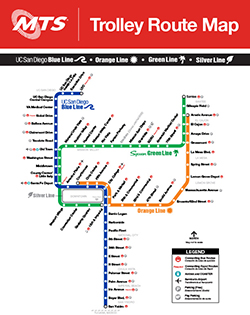
Consider neighborhoods along the UC San Diego Blue Line trolley. (map)
- UTC Transit Center: 8 minutes, est. (neighborhood profile, map)
- Executive Drive: 5 minutes, est. (neighborhood profile, map)
- Nobel Drive: 4 minutes, est. (neighborhood profile, map)
- Balboa Avenue 13 minutes, est. (neighborhood profile, map)
- Clairemont Drive: 15 minutes, est. (neighborhood profile, map)
- Tecolote Road: 17 minutes, est. (neighborhood profile, map)
- Old Town Transit Center: 19 minutes, est. (neighborhood profile, map)
- Washington Street: (neighborhood profile, map)
- Middletown: (neighborhood profile, map)
- County Center/Little Italy: (neighborhood profile, map)
- Santa Fe Depot: (neighborhood profile, map)
- America Plaza: (neighborhood profile, map)
- Civic Center: (neighborhood profile, map)
- Fifth Avenue: (neighborhood profile, map)
- City College: (neighborhood profile, map)
- Park & Market: (neighborhood profile, map)
- 12th & Imperial Transit Center: (neighborhood profile, map)
- Barrio Logan: (neighborhood profile, map)
- Harborside: (neighborhood profile, map)
- Pacific Fleet: (neighborhood profile, map)
- 8th Street: (neighborhood profile, map)
- 24th Street: (neighborhood profile, map)
- Bayfront/E Street: (neighborhood profile, map)
- H Street: (neighborhood profile, map)
- Palomar Street: (neighborhood profile, map)
- Palm Avenue: (neighborhood profile, map)
- Iris Avenue: (neighborhood profile, map)
- Beyer Boulevard: (neighborhood profile, map)
- San Ysidro Transit Center: (neighborhood profile, map)

